Tras varias conversaciones con nuestros amigos de la empresa Lógica acerca de aparatos de topografía y geotecnia, llegamos a la conclusión de que la geotecnia y la instrumentación topográfica no deben estar tan separadas conceptualmente como lo están ahora. Tras mostrarles los datos que estábamos teniendo con las nubes de puntos (ver artículos: http://carreteras-laser-escaner.blogspot.com/2014/08/geotecnia-fractales-y-laser-escaner.html y http://carreteras-laser-escaner.blogspot.com/2014/09/fotogrametria-y-geotecnia-con-visualsfm.html) empezamos a darle vueltas a la utilidad de uno de los aparatos que tenían en su catálogo, el Disto D850 de Leica. Os dejo un enlace por si queréis comparar otros modelos: http://logicaequipamientos.com/productos/buscar/id_categoria=Distos.
After several conversations with our friends in the Company Lógica about geotechnics and surveying equipment, we conclude that the topographical instrumentation and the geotechnic should not be so separated conceptually as they are now. After showing the progress we were having with the point clouds (see articles: http://carreteras-laser-escaner.blogspot.com/2014/08/geotecnia-fractales-y-laser-escaner.html and http://carreteras-laser-escaner.blogspot.com/2014/09/fotogrametria-y-geotecnia-con-visualsfm.html) We think how to use some of the equipment they had in their catalog, as Disto D850 of Leica. I leave a link if you want to compare other models: http://logicaequipamientos.com/productos/buscar/id_categoria=Distos.
Disto D810
Éste es el aparato: This is the unit:
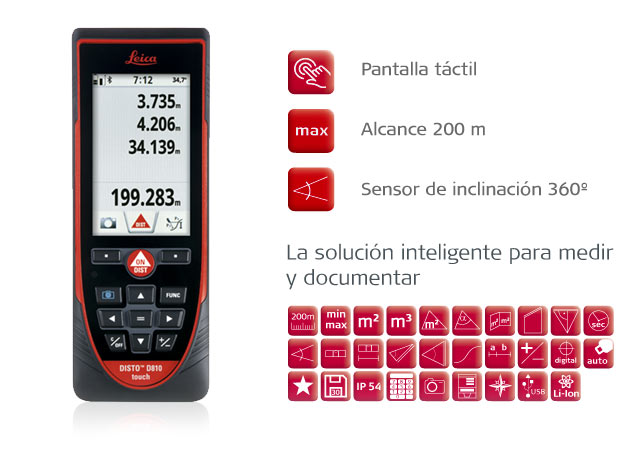
De las funcionalidades que tiene sólo nos interesan cuatro:
- Puede tomar distancias hasta los 200 metros.
- Tiene cámara y zoom, lo que permite apuntar con facilidad.
- Tiene inclinómetro
- Tiene brújula.
- You can take distances of up to 200 meters.
- Has camera and zoom, allowing easy target.
- It has inclinometer
- It has compass.
Los puntos negativos:
- La transmisión Bluetooth de datos necesita Windows 8 y yo no quiero jubilar mi ordenados con Windows XP y por supuesto, no puede funcionar en Linux. Habría bastado con un Bluetooth genérico.
- Los datos de la brújula no se pueden almacenar.
- Hay que ir tomando pantallazos para guardar los datos. Esas fotografías luego son descargables desde USB
The negatives:
- Bluetooth data transmission requires Windows 8, do not want, retire my computer with Windows XP and, of course, can not work in Linux. It would have sufficed for a generic Bluetooth.
- The compass data can not be stored.
- There you go taking snapshots to store the data. These photographs will be downloadable from USB
La toma de datos en campo / Data acquisition in field
Aún así empezamos a hacer algunas pruebas en un talud de una cantera de Cangas (Galicia):
We started to do some testing on a slope of a quarry in Cangas (Galicia):
We started to do some testing on a slope of a quarry in Cangas (Galicia):

Se eligieron dos zonas de estudio, Denominadas Zona A y Zona B:
We selected two study areas, Called Zone A and Zone B:
We selected two study areas, Called Zone A and Zone B:

Y se tomaron varios puntos que presentamos a continuación:
And several points that follow were taken:
And several points that follow were taken:

Transcribir los datos, al no ser demasiados no resulta un tarea muy pesada. Por ejemplo para la zona B, estos datos serían:
Transcribe the data, not being too not a very difficult task. For example for zone B, this data would be:
256.3 5.90 13.448
259.5 7.50 13.960
259.5 6.25 13.940
259.5 5.50 13.930
259.5 4.20 13.910
261.6 6.35 14.445
261.6 5.10 14.403
261.6 2.45 14.314
263.5 6.35 15.576
263.5 4.40 15.487
La transformación de coordenadas esféricas a cartesianas / Spherical Transformation to cartesian coordinates
Para el paso de coordenadas esféricas a cartesianas no hace falta mucha ciencia. Sólo darnos cuenta de que:
Transforming the spherical coordinates to Cartesian does not need much science. You just realize that:
 |
| Esquema básico para el paso de coordenadas esféricas a cartesianas Basic scheme for the transformation of spherical coordinates to cartesian |
Serán por tanto: Therefore
z = Distancia · seno (Inclinación)
x = Distancia · coseno (Inclinación) · coseno (Brújula)
y = Distancia · coseno (Inclinación) · seno (Brújula)
El código en VB es muy simple. Si colocamos la información en un objeto de texto (sea Text_Reg, por ejemplo)
The VB code is very simple. If we put the information into a text object (called Text_Reg, for example)
Private Sub Text_Reg_Change()
linea = Split(Text_Reg.Text, Chr(13) & Chr(10)): If UBound(linea) < 1 Then Exit Sub
datos = Split(linea(0), " "): If UBound(datos) < 2 Then Exit Sub
piu = Atn(1) * 4 / 180 : Text_Sal = ""
For i = 0 To UBound(linea)
datos = Split(linea(i), " ")
If UBound(datos) >= 2 Then
bet1 = CDbl(datos(0)) * piu
alf1 = CDbl(datos(1)) * piu
dis1 = CDbl(datos(2))
z = dis1 * Sin(alf1) - z0
x = dis1 * Cos(alf1) * Sin(bet1)
y = dis1 * Cos(alf1) * Cos(bet1)
Text_Sal = Text_Sal & str(x) & str(y) & str(z) & Chr(13) & Chr(10)
End If
Next i
End Sub
And we have the points in XYZ coordinates relative:
1º -3,1681 12,9962 1,3824
2º -2,5222 13,6088 1,8221
3º -2,5253 13,6251 1,5176
4º -2,5269 13,6337 1,3351
5º -2,5281 13,6403 1,0187
6º -2,0972 14,2024 1,5976
7º -2,0957 14,1921 1,2803
8º -2,0891 14,1475 0,6119
9º -1,7524 15,3809 1,7227
10º -1,7480 15,3421 1,1881
El dibujo de los puntos: / The drawing of points:
El dibujo de los puntos no plantea ninguna dificultad. Lo aconsejable es no complicarnos la vida y simplemente optar por una perspectiva caballera.
The drawing of points does not raise any difficulty. It is advisable to keep life simple and just opt for a cavalier projection.

Unión de puntos para crear triángulos: / Union of points to create triangles:
Decidimos unir los puntos en las siguientes ternas:
We decided to connect the points in the following triads:
9 6 10
1 2 3
3 4 1
4 5 1
2 3 6
3 4 6
6 7 4
4 7 5
9 10 7
7 8 5
7 10 8
1 5 8
Y por ello se crearán los siguiente triángulos:
And therefore the following triangles are created:

Una vez tenemos los triángulos, (con nuestro proceso http://carreteras-laser-escaner.blogspot.com/2014/11/the-simplest-way-to-calculate-plane.html) obtenmos el vector ortogonal y de él deducimos el rumbo y el buzamiento de cada terna de puntos (o triángulo):
Once we have the triangles (with our process: http://carreteras-laser-escaner.blogspot.com/2014/11/the-simplest-way-to-calculate-plane.html)) we obtain the vector orthogonal and him, we deduce the direction and dip of each triplet of points (or triangle):
Ux Uy Uz Rumbo Buzamiento
Strike Dip
Strike Dip
-0,9586 0,2835 -0,0285 → 106,5º -1,6º
-0,7034 0,7094 0,0449 → 135,2º 2,6º
-0,703 0,7101 0,0395 → 135,3º 2,3º
-0,7043 0,7097 0,0177 → 135,2º 1,0º
-0,8053 0,5916 0,0396 → 126,3º 2,3º
-0,8051 0,5921 0,0348 → 126,3º 2,0º
-0,7924 0,6095 -0,0236 → 127,6º -1,3º
-0,7907 0,6121 0,0160 → 127,7º 0,9º
-0,9574 0,2872 -0,0288 → 106,7º -1,6º
-0,7746 0,6306 -0,0497 → 129,1º -2,8º
-0,9574 0,2872 -0,0286 → 106,7º -1,6º
De la media de estos vectores direccionales también podemos deducir el vector de dirección medio y de él el valor medio de rumbo y buzamiento.
From the average of these directional vectors, we can also deduce the vector average direction, and the average value of strike and dip.
Ux Uy Uz Rumbo Buzamiento
Strike Dip
-0,8297 0,5582 0,0031 → 123,9º 0,2ºStrike Dip
Para más información de este tema vea: For more information about this, you could see:
- http://carreteras-laser-escaner.blogspot.com/2014/07/se-puede-hacer-algo-con-el-estudio-de.html
- http://carreteras-laser-escaner.blogspot.com/2014/08/geotecnia-fractales-y-laser-escaner.html
- http://carreteras-laser-escaner.blogspot.com/2014/09/fotogrametria-y-geotecnia-con-visualsfm.html
And more things:
- http://carreteras-laser-escaner.blogspot.com/2014/11/a-extra-dimension-in-triangulation_13.html
- http://carreteras-laser-escaner.blogspot.com/2014/11/a-extra-dimension-in-triangulation.html
- http://carreteras-laser-escaner.blogspot.com/2014/11/the-simplest-way-to-calculate-plane.html
- http://carreteras-laser-escaner.blogspot.com/2014/10/dip-direction-and-schmidts.html
No hay comentarios:
Publicar un comentario