TU ANUNCIO / YOUR PUBLICITY

AQUÍ PODRÍA ESTAR TU ANUNCIO: / HERE COULD BE YOUR AD E-mail

sábado, 15 de septiembre de 2012

Google Maps with centimeter accuracy / Google Maps con exactitud de centímetros

Después de resolver el punto anterior en Bounded-Roads queremos dar un paso más. Queremos unir las plantas del láser escáner con con la planta de Google maps.

El punto de partida es un mapa con esta exactitud:


After solving the previous point Bounded-Roads we go one step further. We want to join the laser scanner levels with Google maps.

The starting point is a map with this accuracy:

Fuente:/ Source: Google Maps
Pero si incrustásemos una retícula de plantas de 10x10m obtenida por láser escáner:
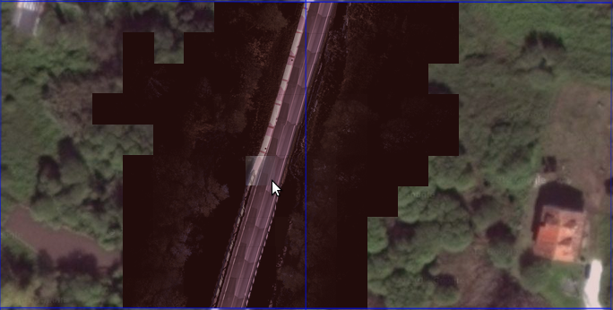
But if we include a grid of 10x10m obtained by laser scanner:


Fuente: / Source Google Maps & Bounded Roads
Si ampliamos una de las piezas:
If we expand one of the pieces:
Fuente: /Source Google Maps & Bounded Roads
Fuente/Source: Bounded Roads
Y la aplicación completa tiene este aspecto:
And full implementation looks like this:
Fuente:/Source Bounded-Roads
Otras operaciones que se pueden hacer:
  1. Obtención de coordenadas con error de 1 cm
  2. Mediciones de segmentos con errores de 1 cm
  3. Visualización de áreas en cuadrícula de 10x10m
  4. Selección de varias cuatrículas y obtención del fichero 3D en formato .las
Y si se quiere con el fichero .las se hace lo que se quiera:


Other operations that can be done:
  1. Getting coordinates with error less than 1 cm
  2. Error measurements segments 1 cm
  3. Viewing 10x10m grid areas
  4. Selecting multiple grids and obtaining 3D file format .las
And if you want with the file.'s Is what you want:


Tenemos a disposición un prisma de 10x10x(lo que sea suficiente).

Para hacer realidad estos pasos visítese: http://carreteras-laser-escaner.blogspot.com.es/p/dividir-en-cuadritos-un-archivo-las.html Aquí explicamos como conseguir tener estos "pixelados" desde uno (o varios) archivos .las.


Have available 10x10x prism (which is sufficient).

To realize these steps see: http://carreteras-laser-escaner.blogspot.com.es/p/dividir-en-cuadritos-un-archivo-las.html Here we explain how to get to have these "pixelated" from one (or more) files .las.

sábado, 1 de septiembre de 2012

GIS data in a map server / Colocando datos en un servidor de mapas

Ahora vamos a situar la información situándola en un servidor de mapas. La primera idea fue utilizar OpenStrettMap pero finalmente la decisión fue tomada hacia GoogleMaps ya que hay que reconocer la magnífica framework https://developers.google.com/maps/documentation/javascript/ y/o https://developers.google.com/maps/. Con poca base javascript añadir objetos y eventos en objetos tipo mapa es sencillo. Además en Internet hay multitud de ejemplos con los que se puede hacer casi cualquier interactuación con estos mapas.

Lo primero es colocar el objeto "Mapa"


Now let's place the information by placing it in a map server. The first idea was to use OpenStrettMap. Settled on GoogleMaps. The framework is superb. (https://developers.google.com/maps/documentation/javascript/ and / or https://developers.google.com/maps/). With some added javascript objects and events in simple maps. Also, on the Internet, there are many examples of how to interact.

The first is to place the object "Map"


1º Se coloca al principio del HTML lo siguiente:
1 In the beginning of the HTML write this:

<script type="text/javascript" src="http://maps.google.com/maps/api/js?sensor=false"></script>

2º Se crea una función iniciadora
2 Inicialize function

<script>
...
var mapa;
...
function initialize() {
var latlng = new google.maps.LatLng(-34.397, 150.644); var myOptions = {
zoom: 19,
center: latlng,
mapTypeId: google.maps.MapTypeId.HYBRID,
zoomControl: true,
zoomControlOptions: {
style: google.maps.ZoomControlStyle.LARGE,
position: google.maps.ControlPosition.LEFT_CENTER
}
};
mapa = new google.maps.Map(document.getElementById("mapa"),myOptions); }
</script>

3º Se añade con un div donde estará nuestro mapa

3 Adding tag <div>

<div id="mapa" style="width:800px; height:300px;"></div>

4º A partir de ahí se continúa con nuestra imaginación, adición de marcas, gráficos, líneas, polígonos, etc. Con un poco de paciencia y una ayudita de google el límite es el que queramos imaginarnos.
4 From there we continue with our imagination, adding marks, graphics, lines, polygons, etc.. With a little patience and a little help from google is the limit we want to imagine.
Ejemplo en /Example in Bounded-Roads
Si además se añade un poco de AJAX para poder hacer llamadas al servidor e intercambiar información  la interoperatividad con los mapas de Google será completa.
With AJAX calls to the server will be able to exchange information with maps.